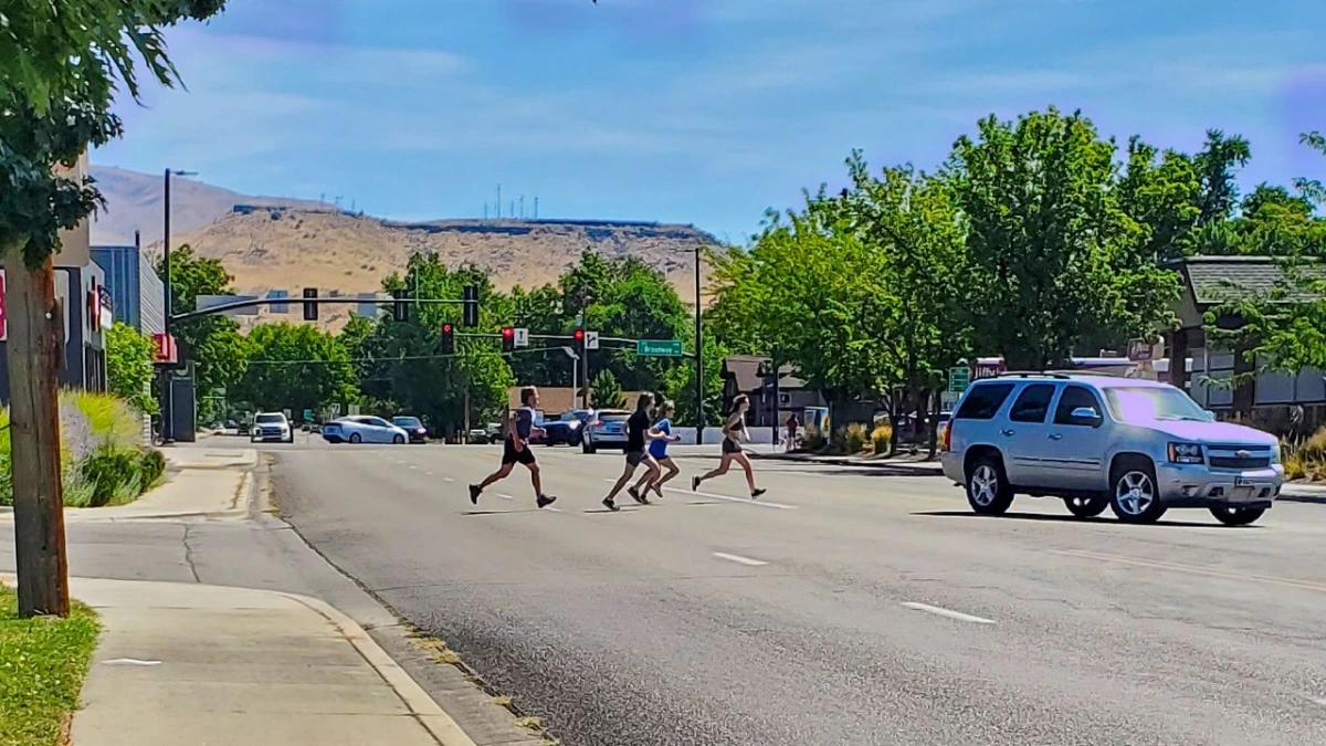
On Broadway Avenue near Beacon Street, four people are running across the roadway. One is several strides ahead, the others follow, and a white SUV is passing along the same broad stretch of asphalt. Farther down the street, traffic signals hang over an intersection. The photograph catches the four in midstride, far enough from either curb that they have to keep going.
Why did they cross there? The signal is about 250 feet down Broadway from where they crossed. For someone trying to get directly across the street, using it could mean walking to the intersection, crossing, and doubling back along the other side. These four chose to cross here. The signal has other traffic to manage.
A good drawing knows a great deal. Engineers have to understand where vehicles can turn, where water will drain and how someone using a wheelchair can reach the other side. Traffic signals must work as part of a network. A decision that makes a single crossing more convenient could make another movement more dangerous. Public works are built with money that belongs to everyone, and a mistake can remain in concrete for decades.
A map makes that work possible by leaving things out. Buildings become outlines, traffic becomes volumes, and a complicated neighborhood can be examined as a connected system. But every proposal also assumes something about the behavior of people who will eventually inhabit it. The assumption may be that they will wait at a certain corner, walk past a particular entrance or choose a newly designed route over an old shortcut.
Those assumptions deserve the same seriousness as the calculations surrounding them. Suppose a proposal relies on people walking to an existing signal instead of crossing midblock. Write down the prediction. Watch where people go before the change, and decide what patterns afterward would make the designers reconsider it. An expected behavior should be specific enough that the people responsible can recognize when reality is giving them a different answer.
Transportation professionals already work with evidence. ACHD’s Livable Streets Performance Measures, first adopted in 2021 and updated following a 2024 evaluation, are one local example. Those measures are easier to interpret when a project has also said what it expects people to do.
Some of that missing information is already written on the ground. A strip of grass turns into a diagonal footpath because the paved route sends people around an edge. Chairs get moved into the shade while fixed seating bakes in the sun. Each records a preference that a plan or survey may never have asked about.
James C. Scott explored this problem in Seeing Like a State. He described how institutions make complicated places legible through simplified descriptions, and how people who work and live within those places acquire practical knowledge that the descriptions cannot fully contain. A model that the street can never correct stops being a tool for seeing and becomes a reason not to look.
The Broadway photograph has a limitation, too. It shows four people willing and able to hurry across several lanes. A parent with a stroller might avoid that trip, while an older resident might drive instead. A count of the people crossing captures only part of the picture. Someone also needs to ask who stays away and why.
Nor does a shortcut automatically deserve a path. A worn track might damage a hillside; a direct crossing might carry unacceptable risks. Repeated behavior is evidence. It gives planners a reason to investigate route choice, speeds, destinations and the people for whom the street is hardest to use. The eventual answer may confirm the existing design. An institution that looks closely can reach that conclusion with more confidence than one that treats every unexpected movement as an error by the user.
A permanent intersection is expensive to change after construction. Safety requirements, legal obligations and the lives people conduct around the road all make public agencies understandably cautious. If the cost of getting a project wrong is high, the instinct is to learn as much as possible before building. More analysis settles some questions. Others can only be answered once an idea is out on the street.
Boise ran an experiment like this in the spring of 2014. ACHD installed temporary buffered bicycle lanes on parts of Capitol Boulevard, Main Street and Idaho Street downtown, adjusting the space available to bicycles and motor vehicles. The agency had held a public open house in March. ACHD collected traffic and bicycle counts and asked the public for feedback during the demonstration.
In a May 22 update, ACHD reported more than 4,660 survey responses and about 500 emails. On the streets covered by the survey, narrow majorities of respondents favored removing the lanes. But the agency explicitly said the survey was not a binding vote. Commissioners also had to weigh congestion, business feedback and the views of the City of Boise and other partners. Public opinion belonged in the decision, though it answered a different question from whether traffic was moving safely and efficiently.
After a little more than five weeks, the temporary lanes were removed. In reporting by Next City, an ACHD representative explained that the commission believed it had learned much of what it needed, faced upcoming construction and had received mostly unfavorable feedback from participants. Critics of the decision argued that five spring weeks were too few to learn whether commuters would adjust their habits or whether the new lanes would attract people who had not previously felt comfortable cycling downtown. How long should the city watch, and what evidence would make either side reconsider?
The 2014 trial also had a second life. In a February 2017 board packet, Capital City Development Corporation said that the earlier bike-lane pilot had validated, in part, recommendations from its 2013 downtown walkability study. By the time CCDC published its 2018 annual report, a protected bicycle lane had been completed along Capitol Boulevard in front of City Hall. This was a different, narrower project, developed through subsequent decisions.
The social psychologist Donald T. Campbell saw this problem long before anyone placed a temporary bicycle lane in downtown Boise. In his 1969 paper Reforms as Experiments, he argued that public officials should be committed to solving a problem while remaining free to change or abandon a particular solution. A reform needs the chance to produce an unwelcome result. Yet officials often have to promise success to win support in the first place. The paint on a road may be easy to remove. The public promise attached to it is harder.
Build the cheapest version of the hypothesis capable of encountering reality. Before a temporary change goes in, the people sponsoring it should say what they expect to happen, what they plan to measure and what result would cause them to change course. They should choose an observation period long enough to answer that question. A five-week trial may be sufficient for one claim and nearly useless for another. Without that distinction, the public can watch the same experiment and come away with opposite stories about what it proved.
New York used a version of this approach in 2009 when its transportation department temporarily changed traffic patterns and introduced pedestrian space around Times and Herald Squares. The Green Light for Midtown project began with stated mobility and safety goals, then measured results against them. Its evaluation reported improvements in travel times and fewer pedestrian injuries, alongside some less favorable findings. In February 2010, the city decided to make the changes permanent.
On Broadway near Beacon, a useful experiment could start without moving a single curb. A first round of observation would count crossings at different times, trace the routes people take and note conflicts with vehicles. Conversations with people who avoid crossing there could reveal what routes they choose instead. If those findings point toward a feasible intervention, qualified engineers could consider a temporary treatment, perhaps a refuge or a revised crossing location, with accessibility and safety worked out before installation. The test should answer a real question without putting pedestrians in danger to make a point.
When a street experiment is proposed, publish the prediction and the evidence that would count against it before the paint goes down. Share what the trial can and cannot establish, then return to the public with the measurements and the reasons for the decision. A result of “not here” or “not yet” can be valuable when it is reached through a fair test. So can an unexpected improvement nobody had predicted.
Between recognizing a problem and committing to a capital project, someone has to observe, test and discover what might succeed. Public agencies cannot turn every block into an open-ended laboratory. Whoever authorizes a temporary intervention must maintain it, preserve access and answer for safety, and use the results to decide what happens next. The ability to learn cheaply is itself civic infrastructure.
Back on Broadway, the four people in the photograph show where an inquiry could begin. Their route cannot settle whether a new crossing belongs there or the existing arrangement should remain. That answer needs traffic evidence, the experience of people who avoid the crossing, and the judgment of those responsible for safety.
The map is a hypothesis. The city gets the last word.